• The River
    • Eagles along the Hoosic
    • Meet the Hoosic
    • The Natural Community
    • The Watershed
      • Virtual Tour
  • About Us
    • Strategic Plan
    • History
    • Volunteers
    • Collaborations
    • Sponsors
  • Recreation
    • Biking the Hoosic
    • Hiking the Hoosic Watershed
    • Paddling the Hoosic
    • Fishing In the Hoosic
    • River Flow Info
  • Education
    • Classes And Programs
    • Issues/Concerns
    • Videos
  • Advocacy
    • Reducing NPS Pollution
    • Remediation Projects
    • Restoring and Protecting Habitat
    • River and Trail Access
    • Sound Land Use
  • Calendar
  • Join/Renew/Donate
  • Blog
    • Facebook

Hoosic River Watershed Association

Hoosic River Greenway

in Blog on 03/09/14

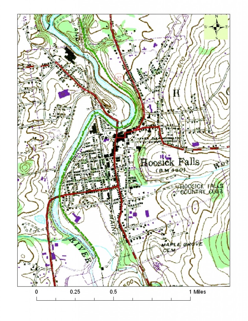
In partnership with the Village of Hoosick Falls, HooRWA proposes to create a Greenway extending for about 2.5 miles along an abandoned rail corridor adjacent to the Hoosic River. The Greenway will run through the Village, and will provide abundant opportunities for walking, biking, running, and winter uses; for floating and fishing access; for historical and nature interpretation; and for other outdoor recreation; as well as affording access to shops and restaurants in the Village’s commercial business district, thereby promoting the Village’s economic development.

For the latest information on this project you can visit the Greenway website at http://www.hoosicrivergreenway.com/. You can also get there from here.

Greenway Path

Greenway Path

The Greenway will provide access to the Hoosic River and surrounding areas so that residents and tourists can enjoy the region’s beautiful environment through recreational and educational exploration. To this end, both land and river access points are to be included in the design elements.

Building the Hoosic River Greenway is a multi-year project with several distinct components, i.e. the design of the trail, including layout of the trail and its access points, design of parking lots at access points, placement of educational kiosks and signage, placement of benches and other amenities, and landscape design. The southern section was resurfaced in 2012. The northern section will be resurfaced later this year. Before and after photos of the southern section can be viewed by downloaded the following pdf file.
Southern section pictures
« The Hoosic River Revival Coalition
Riverworks Past »

E-News Signup

/* real people should not fill this in and expect good things – do not remove this or risk form bot signups */

Water Level


Click on graph to enlarge.
Use your judgment before leaving, if the river feels too dangerous for you, postpone your trip.

Paddling between North Adams and Pownal is usuallly safest when the Williamstown gauge reads 200cfs - 700cfs.

Archive

Past Newsletters

Recent Posts

  • HooRWA Offers River-Inspired Workshops & Classes
  • Notes from the Field: Nitrate Testing Explained

Contact Us


906 Main St, Williamstown, MA 01267 /
PO Box 667
(413) 458-2742
office@hoorwa.org

Copyright © 2025 · Website by Brainspiral

Copyright © 2025 · HooRWA 3 on Genesis Framework · WordPress · Log in