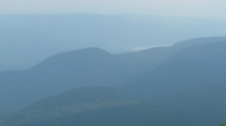
A view toward the Hoosic River from the top of its watershed, on Mount Greylock. Cheshire Reservoir, which holds Hoosic headwaters, is visible in the distance.
A watershed is the region that drains into a particular body of water such as a river or lake. This is why watersheds are also known as drainage basins. A river’s watershed extends all the way to the tops of the hills and ridges that surround the river valley. A drop of water falling anywhere inside the watershed boundaries will eventually make its way down to the river, either in a stream, or over the ground, or under the ground. Taking care of the river, then, means taking care of the whole area that drains into the river.
Major watersheds are made up of smaller watersheds. The Hoosic watershed is made up of al the stream, brook, and small river watersheds that feed into the Hoosic Mainstem. The Hoosick itself is just one section of the Hudson River watershed, which empties into the Atlantic Ocean.
Are you a Hoosician? Most people can tell you what city and state they live in, but not what watershed. This is odd, because people who share a watershed affect each other by the ways they treat the land and water. Everyone is upstream or downstream of everyone else. The Hoosic watershed includes these towns:
Massachusetts: Adams, Berkshire, Cheshire, Clarksburg, Hancock, Lanesboro, New Ashford, North Adams, Savoy, Williamstown.
Vermont: Bennington, North Bennington, Pownal, Shaftsbury, Stamford, Woodford.
New York: Berlin, Buskirk, Cambridge, Cropseyville, Eagle Bridge, Grafton, Hoosick, Hoosick Falls, Johnsonville, Middle Falls, North Hoosick, Petersburg, Schaghticoke, Valley Falls.