• The River
    • Eagles along the Hoosic
    • Meet the Hoosic
    • The Natural Community
    • The Watershed
      • Virtual Tour
  • About Us
    • Strategic Plan
    • History
    • Volunteers
  • Projects
    • Issues/Concerns
    • Videos
  • Recreation
    • Biking the Hoosic
    • Hiking the Hoosic Watershed
    • Paddling the Hoosic
    • Fishing In the Hoosic
    • River Flow Info
  • Advocacy
    • Reducing NPS Pollution
    • Remediation Projects
    • Restoring and Protecting Habitat
    • River and Trail Access
    • Sound Land Use
  • Calendar
  • Join/Renew/Donate
  • Blog
    • Facebook

Hoosic River Watershed Association

Drought status: Abnormally Dry

in Uncategorized on 31/08/20

The Hoosic River and its tributaries are in a drought condition, one stage before Moderate Drought. with water levels near historic lows.

Residents should contacts municipalities for water use restrictions.  For more information on how serious this drought is, go to https://www.drought.gov/drought/dews/northeast .

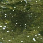
Fish are stressed by low oxygen levels and should not be further stressed by fishing.

Low water conditions may limit boating on stretches of the river.


Trout pool during 2016 drought


« Hoosic River Watershed Map
Rivers and streams, lakes and ponds are abnormally dry »
Paddling between North Adams and Pownal is usuallly safest when the Williamstown gauge reads 200cfs - 700cfs.

Water Level


Click on graph to enlarge.
Use your judgment before leaving, if the river feels too dangerous for you, postpone your trip.

Sign up for our mailing list

Archive

Past Newsletters

Recent Posts

  • Phosphorus and Chloride Testing in Vermont
  • Learning to Fish on a State-Supported Free Fishing Day

Contact Us


906 Main St, Williamstown, MA 01267 /
PO Box 667
(413) 458-2742
office@hoorwa.org

Copyright © 2023 · Website by Brainspiral

Copyright © 2023 · HooRWA 3 on Genesis Framework · WordPress · Log in